Summary
Trees, woods, and forests (TWF) provide multiple benefits to society, including those of social and cultural value.
As such there is a need to increase understanding of the multiple benefits that different types of TWF can provide to the public. Also to explore how management of these spaces can influence synergies and trade-offs of benefits to people at a range of spatial scales.
This research outlines a scoping study which sought to identify and test methods for spatially mapping and surveying the recreation attitudes and behaviours of people living in an area around Cannock Chase National Landscape.
This work contributes to two of Forest Research’s core funded programmes Programme 3 Societal benefits of trees, woods and forests and Programme 5 Achieving multiple ecosystem benefits.
Research Objectives
- Explore the choices and interactions of people in different wood and forest environments, and how these might influence the experience of potential benefits.
- Understand how woods and forests provide cultural ecosystem service benefits at different spatial and temporal scales.
Findings and Recommendations
In our work we tested the following:
- The use of third-party locational data to identify high footfall areas within and surrounding forests and urban areas to inform our sampling strategy.
- Determining a ‘zone of influence’ (10 km from forest entry and car park points) around Cannock Chase National Landscape (CCNL) to inform our sampling strategy.
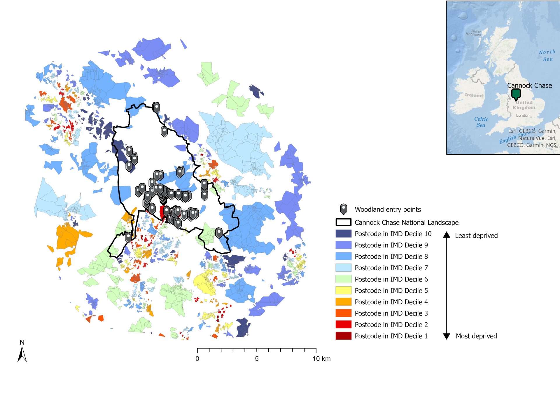
- The use of postcodes as a proxy for surveying people of differing levels of deprivation as measured by the Index of Multiple Deprivation (See Figure 1).
- Sampling three different spatial scales: CCNL, other woodlands within 20 km of CCNL, woodlands within 1 km of where people live.
- Development of a survey questionnaire to explore woodland and non-woodland user experiences and values of woods/forests at three different spatial scales.
- Development and use of an R Shiny (web application) map to capture 3 points along the routes that participants took to explore where they went.
- Evaluation of the method through fieldwork observation and 1-to-1 interviews with contracted surveyors.
- Testing and development of an R Shiny Dashboard to report and share results from the study.
Figure 1: Illustration of postcodes that fall inside one IMD decile. Different colours represent different deciles.
Lessons learnt via the survey approach:
- Focusing on three spatial scales (CCNL, other woodlands within 20 Km of CCNL, and woodlands within 1 km of where people live) for data gathering was useful and shows the importance of larger destination sites with facilities and local woods that are near to where people live.
- Asking survey respondents to map the route they took of their forest visit was problematic in multiple ways.
- An effective strategy is to engage with forest managers and local surveyors at an early stage in the research to identify local woods and locations within woods that are popular and well known within local communities and using local names to help survey respondents in identifying where they have been.
- Shadowing a fieldwork contractor as they collected data from people and interviewing surveyors was very useful in understanding the different approaches surveyors take when out collecting data in the field and the challenges they faced.
Lessons learnt via our spatial approach:
- The use of Huq data (representing people’s movement, passively obtained by their mobile phone apps) and Strava data (representing movement activities recorded by registered users) was somewhat useful in helping to identify hotspots of where people go within and around CCNL and its surroundings to aid identification of survey collection points.
- Use of postcode data based on Index of Multiple Deprivation quintiles ensured we got a spread of respondents of different economic status.
- The development of an R Shiny App to be used by survey participants to map their forest routes was a useful approach for testing applicability of the method. However, survey respondents found it difficult to remember/identify the route they took.
- Using the ‘What Three Words’ (W3W) app was effective in identifying where people entered CCNL and for exploring spatial patterns in the data.
Figure 2: R Shiny app developed to capture 3 points along people’s routes in the forests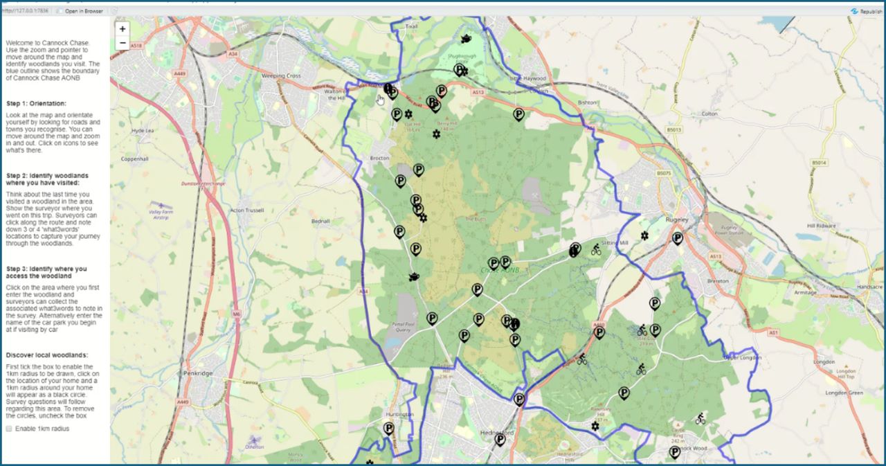
Latest Update
We are currently writing up a summary of results from a survey undertaken in and around the Cannock Chase National Landscape.
Our Involvement
This research was a collaboration between Forest Research’s Society and Environment Research Group and the Land Use and Ecosystems Research Group.