Summary
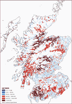
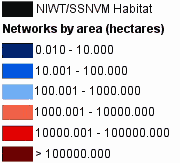
A national map showing forest habitat networks (classified by network size) for moderately mobile (1 km dispersal) woodland generalists
Background
The Scottish Forestry Strategy outlined a major aspiration to develop forest habitat networks (FHNs) through the restoration and improvement of existing woodland and the incorporation of targeted new planting. It is expected that in the longer term such measures will reverse the effects of fragmentation on woodland biodiversity.
The Habitat Network Tool from BEETLE (Biological and Environmental Evaluation Tools for Landscape Ecology) uses a focal species approach to assess the functional connectivity of habitat for specific and generic focal species.
The Scotland FHN project expanded on the Scottish Borders and West Lothian pilot studies to indicate the presence and spatial extent of FHNs at the national and regional scale. The outputs have assisted in targeting grants and incentives for woodland expansion.
Aims
The project developed a plan to support the strategic development and integration of FHNs and open habitat networks in Scotland.
The project produced scenario maps, to help the Forestry Commission Scotland and Scottish Natural Heritage advise on the expansion and restoration of habitats to protect, and enhance, functional connectivity for woodland and open ground species.
Buchan
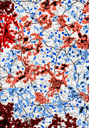
Map (left) shows the extent of habitat networks for mobile woodland generalists in the fragmented woodlands of North Aberdeenshire, Banff and Buchan.
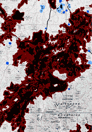
Compare the Buchan map with the size and extent of the functionally connected forest habitat network for mobile woodland generalists in the Spey Valley (below).
Spey Valley
Objectives
- Develop the theoretical basis, based on BEETLE, for a modelling tool to demonstrate habitat networks based on focal species connectivity
- Produce a national map for Scotland showing existing woodland and open habitat networks
- Produce a range of scenario maps for the different regions of Scotland indicating: expansion opportunities and constraints for focal species.
Outputs
National map of habitat networks for woodland and open ground generalists and specialists – April 2005
Regional maps for:
- Argyll and Perth Conservancy and Fife – September 2007
- Argyll Islands – September 2006
- Borders and Lothians – July 2006
- Edinburgh and the Lothians – July 2006
- Grampian Conservancy – March 2007
- Highland and Islands Conservancy – April 2006
- South West Scotland – June 2006
National final report (PDF-4665K) – February 2008
General Content
What’s of interest
The research is funded by:
Forestry Commission (GB)
Forestry Commission (Scotland)
Scottish Natural Heritage