News
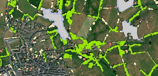
England’s non-woodland trees have been mapped for the first time, revealing these trees make up nearly one third of our nation’s tree cover.
Using LIDAR remote sensing, which involves the very latest methods of laser detection and satellite imagery, scientists at Forest Research have been able to build a comprehensive picture of non-woodland trees the breadth of England. This innovative map is now live.
View the Trees Outside Woodland (TOW) Map

By providing a better national picture, the ground-breaking map will allow conservation groups and local authorities to identify locations of nature depletion and target tree planting efforts more accurately, even being able to pinpoint lone trees that could be easily connected to nearby wooded areas which would create better habitat for wildlife in support of the Government’s manifesto commitment to expand nature-rich habitats and help achieve our legal target to increase England’s woodland canopy to 16.5%.
Forestry Minister Mary Creagh said:
Our precious street trees improve air quality, mark the changing seasons and provide us with peace, shade and joy. Their value simply cannot be overstated.
“This ground-breaking new tree census will not only help us better understand our current tree canopy cover, but allow us to identify areas where we can create more nature rich habitats for wildlife and people to enjoy as part of our Plan for Change”
Sir William Worsley, Chair of Forestry Commission said:
“This has been a real endeavour by the team – the results are spectacular and will be invaluable to us as we strive to meet our legal target to increase tree planting cover.
“The map fills critical data gaps about our national tree assets, helping us understand this natural resource and the benefits it brings, including carbon storage. Many people – from citizens to governments – will use the map to make evidence-based decisions to improve management and protection of our trees.”
Freddie Hunter, Head of Remote Sensing at Forest Research, said:
“This is an exciting moment. By using a combination of aerial and satellite technology, we have been able to locate and measure all trees outside of woodland (TOW) for the first time. By combining the National Forest Inventory woodland map and the TOW map we have a complete picture of tree canopy in England.
“We used laser technology mounted on planes and images of the Earth’s surface captured by satellites to identify tree canopy cover across the breadth of the country. This will be vital in informing future tree-planting and monitoring.”
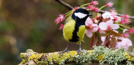
Trees outside woodlands are defined as single trees in urban and rural areas and are some of the most iconic trees in our landscape, ranging from sprawling tree-lined hedgerows to the much-loved trees on our streets and in our parks. These trees play an important role in storing carbon, regulating temperatures, and mitigating against the impacts of climate change, such as flooding and over-heating of our towns and cities. They also have a huge role in improving health and wellbeing – not least by reducing the impacts of air pollution.
The project was funded and made possible by Defra. The government is committed to turbocharging nature’s recovery and the launch of the new map is the latest step to improve nature and tree-planting across our communities as part of the Plan for Change. This follows recent announcements on a new national forest, increasing timber in construction to boost forestry and sustainable housebuilding, and the establishment of a dedicated tree-planting taskforce. The government has also recently announced up to £400 million for trees and peat, as part of the Nature for Climate Fund.
The map is fully automated thanks to its use of spatial datasets and can be updated regularly to capture changes in tree canopy cover. For more information, visit our Trees Outside Woodland page.
The map can be viewed online on the NCEA ArcGIS Online web portal (Trees Outside Woodland) and is free to download from the Forestry Commission open data download website.
Planting woodland adjacent to established woodland or in large clumps is more likely to boost bird populations than random planting, modelling suggests.

Forest Research has announced that Dr Bianca Ambrose-Oji, currently Head of its Society and Environment Research Group, will succeed Professor Chris Quine FRSE as Chief Scientist from June 2025.
England’s non-woodland trees have been mapped for the first time, revealing these trees make up nearly one third of our nation’s tree cover.
Planting woodland adjacent to established woodland or in large clumps is more likely to boost bird populations than random planting, modelling suggests.
Forest Research has announced that Dr Bianca Ambrose-Oji, currently Head of its Society and Environment Research Group, will succeed Professor Chris Quine FRSE as Chief Scientist from June 2025.
England’s non-woodland trees have been mapped for the first time, revealing these trees make up nearly one third of our nation’s tree cover.