There are a range of online tools to assist managers in assessing risks to forests and woodlands and selecting appropriate adaptation measures.
Wildfire
Climate change is leading to warmer, drier weather conditions in spring and summer, and more frequent, prolonged droughts, which increases the risk of wildfires starting and spreading.
Wildfire risk also increases with disease outbreaks, windthrow damage, and changes to climatic suitability affecting vigour, which increase the level of standing and fallen deadwood and litter. According to the UK Climate Risk CCRA3 Wildfire Briefing, the risk of wildfire could double in a 2 °C global temperature-increase scenario and quadruple in a 4 °C scenario.

Threats to forests and woodland
Wildfires are a semi-natural hazard, with most started accidentally from recreational or land management activities, or deliberately. Wildfires can start within forests or spread in from adjacent areas, such as grassland, heathland or moorland. Wildfires start more frequently in areas with high visitor numbers, near areas of socio-economic deprivation, and in areas close to public rights of way. Potential ignition sources include campfires, BBQs, hot oil or particles from machinery and vehicles, or power lines.
There are two periods of high wildfire risk: late winter-spring when there is dead-dry ground vegetation present (e.g., grass, bracken), overnight-frosts, dry periods with low daytime relative humidity; and summer, with hot and dry weather, including heatwaves and droughts. Wildfires during the latter are usually more intense and more damaging. The changing climate is likely to increase the risk of wildfires in both the late winter-spring and summer periods, and may extend the high-risk season into the autumn.
There are three main types of wildfires: surface fires, ground fires and crown fires. The most common is the surface fire, burning fuels such as heather, grass, bracken and gorse. Surface fires can burn fiercely, spread fast with long flames and at high fire intensity. There can be substantial growth of these fuels along roads and rides, before canopy closure, and after woods have been thinned. Ground fires consume peat and soil organic matter and threaten carbon stores. Smouldering peat fires are hard to extinguish and can re-kindle frequently.
Crown fires occur less frequently, during hot and dry summers, but are the most dangerous. They spread from surface fires, with ladder fuels, including tall shrubs, low tree canopies, standing deadwood and trees in poor health, and leaning windblown trees increase the risk of canopy fires.

Impacts of wildfire
Wildfires can have devastating consequences for people, property, industry, and the environment. The impacts of wildfires in forests are:
Economic – loss of tree stock and revenue, including ‘downstream’ industries such as wood processing, tourism and recreation. Disruption to transport, infrastructure and surrounding businesses.
Environmental – habitat and species loss, carbon loss, run-off, pollution, and smoke.
Social – health threats to forestry workers, visitors, and communities; disruption impacts on infrastructure, transport, and property.
Wildfire risk
- A site is at higher risk of a wildfire starting if there are potential sources of ignition on-site or nearby, including a history of wildfire events, high visitor numbers, recreation routes, camp sites, lay-bys, or car parks.
- Habitats with a high fuel load have a higher fire hazard, including sites with dense surface vegetation (open areas, rides, young woodland before canopy closure, scattered trees), flammable species (bracken, gorse, eucalyptus, cypress, pines), extensive areas of brash, dead or dying trees (disease outbreaks, windthrow damage, low species suitability).
- Conditions which increase wildfire hazard include south facing sites, slopes and gullies, drought prone soils and dry organic peat soils.
- Wildfires can spread and intensify if there is a delay in detection or response, with remote sites at greater risk. Restricted or blocked access routes, weight limits, and limited water sources can delay or inhibit response.
- Wildfire risk is also related to the assets at risk on site or nearby, including staff and recreational users, industrial or residential areas, buildings, infrastructure, utilities, equipment, property, priority habitats or species, historical features, or significant carbon stocks.

Source: Building wildfire resilience into forest management planning – Forestry Commission Practice Guide

Adaptation measures
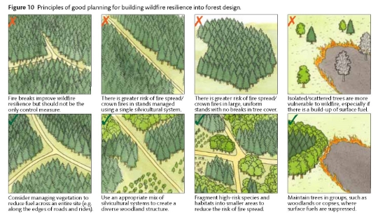
Risks from wildfire can be reduced through good practice in forest design, planning and operations. Wildfire resilience measures can address potential ignitions sources, fuel load, minimise wildfire spread, protect assets and support response. Wildfire hazards and risks should be considered when planning a new woodland, and resilience measures included in existing design plans.
- Across the woodland area, plan regular fire breaks of sufficient width to the vegetation height to create discontinuous blocks. Roads, rides and natural features can be incorporated, and naturally resilient features, such as riparian areas, can be linked to fragment high-hazard areas.
- Protection areas should be planned in areas at high risk of fire entry or ignition and surrounding assets, including fire breaks and zones with prescribed management of ground vegetation, deadwood and brash. Highly flammable tree species and habitats should be avoided.
- To aid incident response, access roads with passing places, turning points, and a hard standing area should be incorporated, if possible, ensuring road & bridge weight limits support HGVs. Routes to open hills, access routes through boundaries, and gates through deer fences are important. Where possible, ensure sufficient water resources are available, such as fire ponds near the top of hills.
- Forest operations play a significant role in reducing wildfire risk. Operations should be timed to avoid high-risk conditions where possible. Vegetation and regeneration should be cleared in prescribed areas, during woodland establishment, along fire breaks, and regular, targeted swiping carried out along rides and roads. Brash and deadwood levels should be managed in high-risk zones, however deadwood is an important component of a properly functioning forest ecosystem, sustaining biodiversity and soil fertility, and outside high-risk zones, levels should be maintained according to UKFS guidelines.
- Regular tree health assessments should be carried out, with appropriate clearing and handling of diseased trees. The timely removal of wind throw, trees in poor health, under-performing stands should be planned, with the priority in high-risk areas.
- Access routes should be kept clear. Equipment and machinery should be maintained, and best practice in fuel use & storage followed.
- Incident response planning and fire maps can assist Fire and Rescue Services (FRS), reduce response times, aid suppression, and minimise impacts during an incident. Engagement with Fire and Rescue services, neighbouring landholders, and local wildfire groups can support land-scape scale resilience.
For further information see Forestry Commission Practice Guide 22 Building wildfire resilience into forest management planning.
The adaptation measures listed below can help reduce the incidence and impact of wildfires in forests and woodland.

Case study
Discover how adaptation measures were selected following a 10-day forest fire in 2011.


